
Trail Name: Pillar Lake
Distance: 1 km
Time: Under 1 hr
Difficulty: Medium
Cell Service: No
Trail: Single track switchbacks
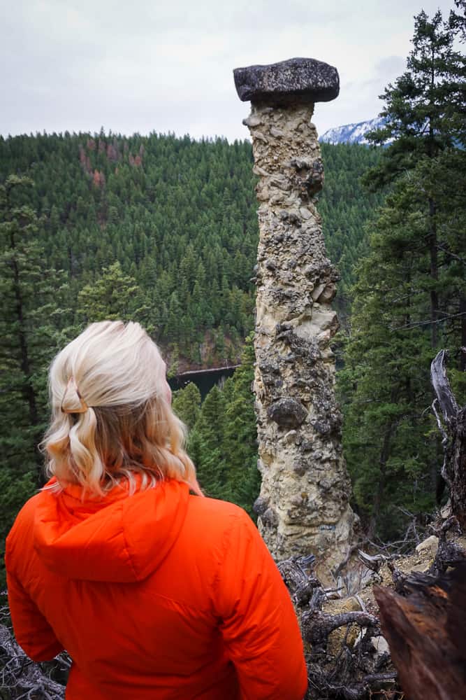
Highlight: The Pillar!
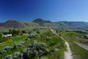
To get there: This hike is about an hour’s drive from Kamloops. You can get there a number of ways (through Falkland, Chase, or Pritchard). It is situated on the Chase-Falkland rd. Get directions here.
Once you approach Pillar lake, keep an eye out for the Pillar Lake Rec site sign on the lakeside of the road. Pull off here and continue down the little road until you see a trail heading up to your right. Park here. Follow the trail back up to the road and cross to the other side. You should see the trail sign ahead of you. From here, follow the trail up to the Pillar. Remember to stay on the trail and respect all signs.
This trail is lovely and very short! After a short, steep climb, you will reach the Pillar. It really is a magnificent sight to see! The pillar is about 28 meters tall with an 8 ton rock balancing on top! If you’ve never been before, we definitely recommend you go check it out. As always, please be respectful and cautious around the Pillar.


Cathy
5 Jul 2017Pillar Lake – As this hike is only 1 km, are there any other hikes in this vicinity to tack onto this hike?
Hike Kamloops
5 Jul 2017Hi there! Not that we know of.. granted we’ve never really looked into it. We usually spend our time at a nearby rec site or on the lake! Unfortunately, you’ll have to take a look on Google because we’re not sure! Good luck!
Jill
1 Nov 2018Just wondering about the history and magnificence of this pillar?
Hike Kamloops
2 Nov 2018From a quick google search, it appears to be of cultural significance to the local First Nations.
“Coyote’s Marker – Pillar
Sk’elpakw, known as Pillar Lake, is the lake between Falkland and Chase, B.C. Sk’elpakw is an important hunting and fishing area for the Secwepemc. Above the lake, is the one of the Coyote rock markers. Coyote traveled throughout the land of the Secwepemc and marked out their territory by rock markers.
Long ago Coyote traveled around on Secwepemculecw (land of the Secwepemc). He helped make the land a better place for the Secwepemc. He helped them in many ways, such as putting fishing rocks by the rivers.
As Coyote was traveling on the land, he placed many land markers on the land. The markers are made out of rocks and are many different shapes. He put them on the land to mark out the territory of the Secwepemc. The Secwepemc know the boundaries of their territory by the markers Coyote placed on the land.
The Pillar is one of the land markers made by Coyote.”
And here’s another story and some background on the formation of the pillar.
“The Falkland hoodoo has been awing people ever since it was first discovered. The natives of the area had a story of how this impressive sight came to be. It was once believed that the water spirit of Pillar Lake took a native maiden as a partner as she was canoeing on the lake. The parents of the unmarried woman were very distraught that they never had any news of their daughters life. To appease the parents, the water spirit built the hoodoo with the boulder on top and said to them that if their daughter were ever in grief then the rock would fall off the top. To this day the boulder stands strong and proudly displays the young native girls happiness.
The Falkland hoodoo is a staggering 30 meters (90 feet) in height. Balanced atop the conglomerate of sedimentary rock is an eight-tonne boulder. Hoodoo is the term that is used mainly in Western North America. In other parts of the world, earth pillar is the common used terminology. There are two distinct types of hoodoos; the one standing in front of you is sedimentary in nature but volcanic hoodoos also exist. Regardless of which material the hoodoo is formed from, where or how; they are all created the same way. The driving force behind the creation of hoodoos can be attributed to erosion. This erosional remnant protrudes above the surrounding topography due to differential weathering. This is the terminology that geologist use but it only means that the rest of the landscape surrounding the hoodoo was eroded at a much faster rate than the hoodoo itself. The steep sided slope that used to encompass the pillar is eroded back leaving the hoodoo standing proud. Nature constantly assaults all features on earth as the sun, water (flowing and freezing), wind, temperature (freeze/thaw cycles), gravity, etc. all play a part in the erosion of the earth. Just you walking up here and carving your name play a part in further eroding the mountain and hoodoo.
This impressive conic tower is topped with a boulder that is referred to as a caprock. It may seem surreal or unbelievable that a boulder could get to the top of this structure but if it were not for the caprock then this geomorphologic structure would not exist. The caprock protects the structural integrity of the column much like a roof shields a house from the elements. The surrounding landscape was eroded away because it was not protected by a caprock.
One day the forces that created this spectacle will also destroy it. The hoodoo and caprock can only withstand the forces of erosion and gravity for a limited time period. Once the caprock has stopped shielding the rest of the column then the erosional activities will take over and topple the Falkland hoodoo. This will mean that the water spirit of Pillar lake has done something terribly wrong.”