
Trail Name: Skoatl Point
Distance: 10.3 km
Time: 3+ hours
Difficulty: Hard
Cell Service: No
Trail Conditions: Single track through the forrest, followed by a scramble up a volcanic plug.
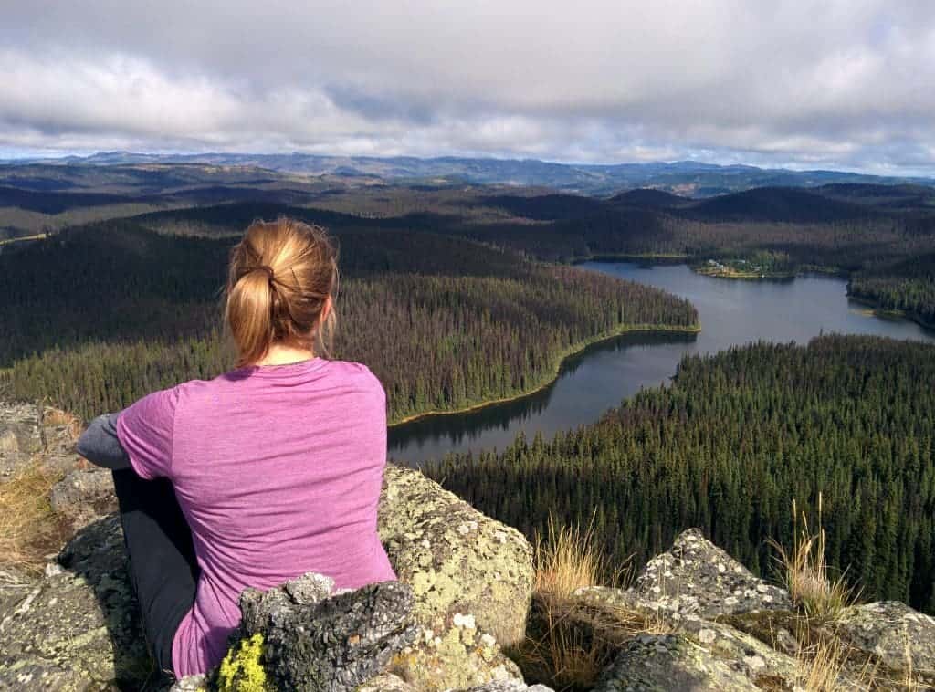
Highlights: Amazing 360 degree views and a scramble up a very unique geological formation.
To get there: The trailhead is a good 2 hour drive from downtown and you must have a vehicle with good ground clearance to make it to the trailhead. From the North Shore, take 8th street all the way out to where it turns into Westsyde rd. Continue on Westsyde rd for about 20 kms before turning left on Jamieson Creek FSR. Continue for about 30km until you pass Whitewood lake. You’ll see a large piece of heavy machinery at a fork, take the left towards Windy Lake. You’ll come to one more fork just past the Windy lake rec site (about another 9km in). Keep to the right. You’ll reach the trailhead shortly. Or see it on Google here. (These are the best directions to get here!)
The trail head is clearly marked with a BC Parks sign. The trail is linear. In the early summer, the area is often swampy, wet, and full of mosquitos. We recommend doing the hike in late summer or early fall. The trail is not heavily used, but it is still easy to follow. When you approach Skoatl point, you’ll want to follow the trail around to the right of the rock formation. There’s some flagging tape to help guide you across the rock slides. There were many fallen trees the last time we were up there, making this route a bit harder as you try to manoeuvre around them. Continue around the perimeter until the trail leads you to the rock face. Here’s where it gets interesting. The trail disappears and you must choose your own route up the side of the volcanic plug. BE CAREFUL! At the top you get a 360 degree view of the surrounding lakes.
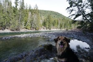
The trail to the base of the plug is suitable for anyone however, the scramble up to the top of Skoatl is difficult and steep. Some may decide to turn around at the base. Our medium sized dog was not able to do the scramble and she is too big to carry. Smaller, more portable dogs, could be carried to the top. You might also consider bringing a lunch as it’s a long drive and a long hike. There are two rec sites along the road you came in on that are lovely spots for lunch. The area is also known for bears so bring bear spray and hike in groups.
If you have time, check out Jamieson Creek Falls! This short hike is along the same road as Skoatl Point and brings you to a beautiful waterfall.


Pedro
24 May 2016May 23,2016 just went there for the first time, only a small amount of water on the trail … great hike will be going back to see the Jamieson Creek Falls soon.
HikeKamloops
25 May 2016Oh thats awesome to hear! Thanks for the heads up! Aren’t the views amazing?!
Katherina Gountas
22 Jun 2017Any idea if the May 2017 washout is cleared up? We had made plans to hike it this weekend and then I saw the update on the page 🙁
Hike Kamloops
22 Jun 2017Looks like it might be all good to go. I check this website for my info 🙂 https://www.tranbc.ca/southern-interior-flood-recovery-travel-advisories/#SA15
Good luck!
Hike Kamloops
22 Jun 2017Also, please let us know if you do make it up so that we can update the page to say all good 🙂
Austin
30 May 2020Hike is loaded with fallen trees and swampy.
Mike
3 Jul 2017The trail is in fine condition with a moderate amount of blowdown. Not much mud and the boardwalks are in good shape. Lots of lupins, lilies and columbine in bloom. Osprey and loons on Adler lake.
Unfortunately the Jamieson Creek FSR is now closed. I got through this morning at about 0845, as the chain gate at the first bridge had been lowered and was laying on the road. The road has numerous serious washouts that have narrowed it to one lane and several repaired portions where water had run across the road, but nothing I couldn’t get around or over in a small 2WD toyota pickup. The chain gate had been raised again when I returned (thankfully it was still only about 8″ off the road) which forced me to stack up rocks and gravel to get over it again.
I heard later that this road is going to remain closed indefinitely. If you manage to make it over or through a gate on the way up, don’t count on it being open again when you come back…. figure out an alternative return route.
C.B. Villeneuve
23 Sep 2017We made it today on September 23, 2017. The bridge on Jamieson Creek Road is still missing, but you have to take O’Connor Road (From Westside Road), and turn on Wentworth Forestry Road that will take you to Km15 of Jamieson Creek Road. From there it is clear sailing to Whitewood Lake, where you turn onto Windy Lake Road.
Someone had been there lately with a chainsaw and cleared many windfalls that were blocking the road. But there are still a few on the trail, no problem you can walk around. I was surprised to see how good the trail is; it gets a bit dicey at the base of the plug where you have to walk on rocks before starting the real climb.
The Geocache box is in the open at the base of the flagpole, and I agree with that! If you make the effort to go there you should not have to look all over to find it.
From the summit I sent an OK with my Spot Tracker, and it reported the co-ordinates as Latitude: 51.15430 Longitude: -120.43034
I’m 75, and if I made it then anybody can!
Jodi Kemp
17 Sep 2018Does anyone know if the road to Skoatl point is clear?
Tarra
26 Sep 2018Is the road to skoatl accessible by car ?
Hike Kamloops
28 Sep 2018From what I remember of last time – no. Most of the drive would be okay, but towards the end, there was a really narrow road through thick trees with a deep dip (like a reverse speed bump but deeper). We were worried about it in our SUV. If possible, I would try to use a high clearance vehicle. Also – let people know where you are headed as there is no service up there if something was to happen.
Theresa
13 Aug 2019Has anyone been up to there this year? How is the road past Windy forestry camp site and the trail in? Any comments welcome.
Hike Kamloops
25 Aug 2019Some friends of ours were up in the early spring and said there was quite a bit of windfall. Haven’t heard any updates since.
Stephanie
7 Sep 2019We were up there today and the majority of the windfall had been recently cut through and made it easily passable. There’s a few logs to climb over and crawl under but not bad!
Hike Kamloops
8 Sep 2019Thanks for the update Stephanie!
Deb
11 Sep 2019I was up there May long weekend..lots of windfall from Adler Lake on..but you can work around it.It will ad time to your hike for sure.The view is worth it if you have the time.
Jayme
8 Sep 2020We did this trail over the weekend and it was in great shape. The last few hundred meters is brushed in but easy to navigate. We didn’t make it all the way to the top as we had little ones but it was a great fall hike.
Will
29 Sep 2020The trail was in excellent condition today. The windfall has been cleared away (that was there last year) and the trail is mostly dry. Lots of fish jumping at Adler Lake, and whiskey jacks flying around to see if we had any treats for them. Have down this hike a few times, and it won’t be the last. Worth it!!
Simon Griffin
23 Aug 2022Trial is closed. BC parks sign crossing trail head. Fire in June for 2021 has burnt most of the area. All bridges are gone and lots of dangerous trees hanging.
Hope it will reopen some day but it’s going to be lots of work to get it there.
Alanna
27 Sep 2022The trail is closed. Went up yesterday and there are signs once you get the drive entrance that say road closed . There were bc parks trucks parked in the parking area and more closed signs at the trail head. Not sure why, just wanted to let people know so they don’t make the trip for nothing.