

Trail Name: Albas Falls
Distance: 4.7 kms
Time: 1.5 hours
Difficulty: Medium (as long as you obey ALL signs!)
Cell Service: Intermittent
Trail: Single track through the forest, on rough rocky and stumpy terrain. Precarious at times near the waterfalls
Highlights: Some of the MOST amazing falls we’ve ever seen!
To get there: This trailhead is about a 2.5 hour drive out from Kamloops and is located just before Seymour Arm. From Kamloops, head East along the Trans-Canada Hwy. Continue on the highway for about 65kms. Just past Chase turn right onto Squilax-Anglemont Rd and head over the bridge. Continue following this road another 46km past Scotch Creek, past Celista, past Anglemont, and through St.Ives. Just past St. Ives, the road turns to dirt but is fairly well maintained with no potholes and just a bit of washboard. Continue down this road for another 30kms. Between the 30 and 31 km marker, keep an eye out for the sign on your right to Albas Provincial Park (we almost missed it!). Turn right down the road and follow it for another 2km. This road is quite narrow and full of deep potholes, so take it easy! At the bottom, you should see a signboard warning about the seriousness of this hike, turn left here and continue another 0.5km down the road until you see the bridge. Park here.
Get directions on Google here.
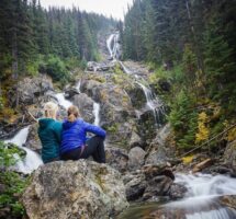
At the base of the trail here, you should see another sign. This one has the trail map on it. There are multiple trails to take, but we recommend taking the left as it offers the best views of the falls! Granted, as a fellow hiker mentioned, if you want to save the best for last, take the trail over the bridge first and loop around to see the falls on your way back down.
We took the trails to the left which heads directly to the falls. Follow this trail along the creekside for a ways until you see the falls. After taking your pictures, continue along the trail to the left. You will climb up the rocks and come out alongside the top of the falls. From here, cross over the small bridge to traverse a side chute of the falls. From here, there are a few consecutive waterfalls. Continue following the trail until you reach the bridge at the top of the trail. Here you can choose to go down the way you came, down the main access road which is nearby, or cross the bridge and follow a trail down the other side of the creek. The other side of the creek is a much easier and less technical hike, but it does not offer much in the way of views.
Please obey all posted signs. People have died in this park. You will come across a memorial plaque midway up the trail.

Fernando
28 Jun 2021Thanks for the directions and data. We did the full hike loop, starting from the left trail before the bridge. Beautiful views. Thanks a lot for this post,
Fernando