Trail Name: Enderby Cliffs
Distance: 15.6km
Time: 3+ hrs
Difficulty: Hard
Cell Service: Unknown
Trail Conditions: This is a very well maintained single track dirt path. There are some steep sections but they are in fairly good shape.
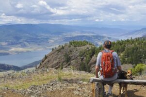
Highlights: With a net gain of nearly 700m, this hike offers spectacular views of the Shuswap River valley. At various points along the path, the trees open up to amazing views, but it isn’t until you reach the summit where you’ll be treated to the best panoramic views in the area.
To get there: This hike is a little ways out of Kamloops, but is well worth the drive. The trailhead is located just outside of Enderby BC. Enderby is located south of Salmon Arm and North of Vernon. Check google maps and take whichever route you’d like, either way is roughly 1.5hrs from Kamloops. Once you arrive in Enderby, turn down Cliff Ave. This is one of the main streets in the small town and will lead you to a small bridge over the Shuswap River. Once over the bridge, follow the signs towards Enderby Cliffs. About 1.6 km from the bridge, turn left onto Brash Allen Rd. Stay on Brash Allen Rd for 3km. The road will come to a dead end, and you’ll see signs and a parking area on your left.
There is a well signed parking area at the end of Brash Allen Rd complete with outhouses. The parking lot is a one way circle, with the access to the trailhead near the entrance. The trail begins immediately across the road from the parking lot. Please respect the owners of the private property and use the trail that runs parallel to the driveway on the left.
This hike is a linear hike. You will be returning down the same path you ascend. Expect the first half (7.8km) of the hike to be a long constant climb with very few flat sections.
This hike is not for the out of shape. The long, arduous ascent could be too much for many. During the summer months, avoid the climb during the hotter parts of the day. There are some shady sections, but in the heat of the summer sun, heat stroke and exhaustion could be a serious threat. It would make a great morning hike with an early lunch at the summit while taking in the views.
The trail is dog friendly with all the same warnings as for humans. Make sure the dog is in good shape, listens well and has had lots of hiking experience. There’s no water along the path, so be sure to pack extra water for yourself and your canine companions.
The first 4 or 5 kilometres of this hike are up steep switchbacks to the top of the hill. Once you reach this point, the remainder of the hike follows along the edge of the cliffs until you reach the summit. Please be extremely cautious along this section. The cliffs are 600-700m in elevation and there are no railings or any protective measures. In some spots, the edge of the cliff is loose dirt. In no part of the hike does the trail force you into close proximity with these rather extreme drop offs. However, be aware that they exist and could be hazardous if you, a fellow hiker, or dog venture too close.