

Trail Name: Gibraltar Rock II
Distance: 6.7km
Time: 1 hr 45 mins
Difficulty: Medium
Cell Service: none
Trail Conditions: The entire trail is single track packed dirt and rock.
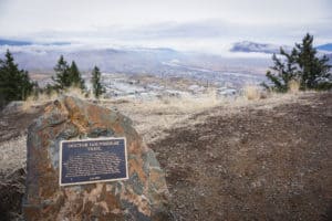
Highlights: This hike offers both a nice flat stroll along the lake followed by a long ascent up some switchbacks, to the top of Gibraltar Rock giving way to some beautiful views of the Paul Lake area.
To get there: Head north on the Yellowhead highway (Hwy-5) before turning right onto the Paul Lake Rd. In 12km the road will fork, keep to the right to stay on Paul Lake Rd for another 2.5km. Just as you’re about to enter the Paul Lake community, you’ll notice a concrete barrier coming up on your left. You can park in the boat launch area just before the concrete barrier so long as you’re careful not to block lake access. Or, there’s additional parking around the corner on your right immediately following the concrete barrier. Or get directions from Google here.
The trailhead is marked by some signage and a brown fence to the left of the boat launch. This trail is a linear that could easily be split into two parts. The first 2km hugs the shoreline closely and brings you to a cozy bench. Some may choose to turn around here for a relaxing 4km lakeside stroll. For those who want more of a climb with rewarding views, continue to the left at the bench and begin your ascent. Around the 3km point, you’ll come to a well signed intersection of 4 trails. Head straight and continue until you reach a second intersection; this one has a bench. Turn right to begin your final ascent to the top. Once you’re on your way to the top, the trail may split and fork a few times, but all paths lead to the summit. Just keep climbing and you’ll get there!
This trail is quite popular among local hikers, mountain bikers and their dogs. People of all ages were on the trail including young families at the summit having lunch. The vast majority of this trail is in the shade, but only the first (and last) 2km is close to water. If you’re bringing your dog, be sure to pack some water for them at the top.
If you’re looking for a slightly longer hike, you can continue straight at the second intersection and head across to the Paul Lake Provincial Campground. We’ve detailed this trail from this side here.


Renna
25 May 2017Hi! Was wondering if high water would affect this hike at all?
Hike Kamloops
25 May 2017Hi Renna, we’re really not too sure. We haven’t been up to do the hike since the winter. I have seen a number of posts on Instagram from people who have done the hike, but I’m not sure if they’ve done it from the Provincial Park side or the condos side. Sorry!
Mike
6 Jan 2021Hi! What are the road conditions like to get up in the winter?
Hike Kamloops
6 Jan 2021Hi there, this is the same road you would take to access Harper Mountain, so it should be maintained year-round. The only concern might be trying to find a place to park, but it is quite a popular trail for residents as well, so you should be able to figure something safe out. NOTE: this access point is not in the Provincial Park itself. The park’s gates are closed for the season.