Trail Name: Margaret Falls
Distance: 1.5km
Time: 20 mins
Difficulty: Easy
Cell Service: Yes
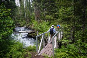
Trail: Wide, lined dirt path through the forest and over multiple wooden bridges
Highlight: The creek, the lush forest, the old growth, and the stunning Margaret Falls.
To get there: This trail is about a one hour drive from Kamloops. To get there, take Highway 1 heading East towards the Shuswap. Continue on the highway for about 91kms. Turn left onto Sunnybrae/Canoe Point Road, following the signs to Harold Provincial Park. Continue down this road for another 12kms. As you approach you should see signs for Herald Provincial Park. Continue just past the park itself, and watch for a sign and parking area for Margaret Falls on your left. Park here.
IF the parking area is full, DO NOT park on the side of the road. Instead, continue down the road another 1km to the Day Use Area on the right. Head towards the far side of the parking lot and you should see the Margaret Falls sign. Park here. Or get directions from Google here.
From the Margaret Falls parking area, take the trail past the outhouse as it passes alongside the road. From here the trail follows the creek bed through a lush forest for less than 1 km. You will pass over 3 wooden bridges before finally reaching the falls and the new viewing platform.
This trail recently re-opened thanks to BC Parks after a flood washed out the trail in 2017. We are so pleased the trail is open again. The falls and the trail are well worth a trip. If you’re in the Shuswap area, check out some of our other hikes in the area.