

Trail Name: Mara Loop
Distance: 4.3 km
Time: 1.5 hrs
Difficulty: Medium
Cell Service: Yes
Trail: The trail starts as double track ATV/4×4 road as it climbs above the plateau. It then turns into a single track packed dirt trail with sections of loose rock.
Highlight: A nice shoulder season loop through the Kamloops desert.
We have a newfound appreciation for this trail. This trail is a full-sun trail through the Kamloops desert so we do not suggest doing this one mid-day in July or August. It is much more enjoyable in the shoulder seasons or as a sunrise/sunset hike. Also, we strongly prefer doing this trail clockwise (opposite direction from all the signs) as it is easier to follow.
To get there: This trail is about a 20 minute drive from downtown Kamloops. Follow Tranquille Dr towards the Kamloops airport. Continue down the road past the airport and the golf course. When the road forks, keep to the right and head over the train tracks. About 210m from the train crossing, you’ll see a pull off on the right with signage for the Mara Trail. Or get directions from Google here.
Park on the side of the road in the pull out. The trailhead is in front of you through the wood gate. From here, head in the opposite direction of all the signs, taking the the dirt road to your left (Pruden Pass Rd). Stick to the main road as you climb for about 1.8km until you come to a bit of a plateau. Keep your eyes open for the white back of a trail sign on your right. Turn right off the road here and continue to follow the Mara trail in front of you. Again, keep an eye out for the white back of the trail signs as you start to descend off the plateau. At about the 3.5km mark, you’ll come to the bench viewpoint. Be sure to enjoy the view before continuing down the trail back to the parking area.
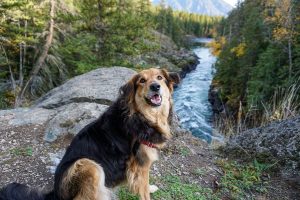
We found doing this trail in the clock-wise direction so much easier to navigate. The white backs of the signs were easy to spot and it was nice to end the hike near the bench viewpoint. This hike starts off with quite the climb, however it’s no steeper than the Tower Trail. There are a couple sections on the way down where the gravel is loose and the trail is a little steep. Overall this trail would be suitable for most. The trail is dog-friendly (BC Parks on-leash) however, there is a prickly pear cactus all over the sides of the trail. This is also rattlesnake country, so keep your ears open as you hike.


Emily Anderson
25 Jun 2018Oof this one sure could use some more signs! I tried to choose the trails that appeared most well-travelled but still got way off base before even the first kilometre— never found that bench! And I definitely did not bring enough water to allow me to test out and backtrack every fork I encountered!
Hike Kamloops
25 Jun 2018Hi Emily, we understand COMPLETELY! This trail is definitely one of our least favourites due to the lack of signage and lack of shade. We did our best with the directions, but alas they wont ever be perfect. We hope you still had an enjoyable time and will check out some of the other fantastic trails in the area!
Emily Anderson
26 Jun 2018Oh I understand! I don’t know if it’s got worse since this post or I am just bad at decisions! We still had a good little explore and found some views. I’ll definitely give it another go some time!
Thanks for all the great info on this site!
Josh Matheson
21 Sep 2018I found it easier to do the loop backwards (clockwise). This way you start with the easy to follow double track road. Then you just have to turn onto the correct single track trail, which is right beside one of the arbitrarily placed “mara loop” signs. After this it’s all downhill on the single track, and easier to find your way back.
Hike Kamloops
22 Sep 2018What an interesting idea! We’ll have to try that next time for sure! Thanks for sharing!
Bill
16 Apr 2021There is a Second bench there! It is on the hill that you climb right after the first bench (assuming you go counter-clockwise). Once you ascend the hill, turn left onto a short trail to the second bench with a nice view.