

Trail Name: Savona Caves
Distance: 4.2 km
Time: 1.5-2.5 hours
Difficulty: Hard
Cell Service: Unknown
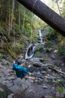
Trail Conditions: The first 600m or so is a relatively flat single track dirt trail. The remainder of trail is a steep single track path with numerous sections of loose rock and dirt.
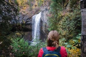
Highlights: The views of the valley from the caves are amazing. Don’t forget to turn around and explore the depths of the caves too. There are numerous Indigenous pictographs on the rocks.
To get there: The drive is 45 minutes from Kamloops. From Kamloops, take the Coquihalla (Hwy 5) towards Vancouver. Take exit 362 to Hwy 97N towards Savona. In 30km, turn left onto Tunkwa Lake Road. In roughly 11km, look for a logging road with cattle guard your right. Turn right and head another 500 meters past the cattle guard. You’ll come to a leftward bend in the road. The trail head is marked with ribbon on the right side of the road at this bend. See it on Google Maps here.
We often park just off the road on the right. If your car has enough clearance to get through the ditch, there’s plenty of room to park here. Otherwise, there is a small pull out on the left of the road. Just be sure to get off the road as much as possible as it is narrow. The trailhead is well marked with ribbon. It’s a linear trail and has been marked with red ribbon so it should be fairly straight forward to follow.
This trail is perhaps one of the most challenging we’ve posted on this site so far. The first section is fairly flat and accessible. However, once the climb begins, it is fairly relentless with numerous sections of loose rock and dirt. A few sections will require use of your hands to get up. Although we did cross paths with a few grey haired hikers, I would suggest only those with good shoes, good balance and strong legs attempt this climb. The views from the top are worth it as you look back at the valley and explore the caves! This hike is dog friendly.

Anand
25 Apr 2016Planning to go there tomorrow 😀
Thank you for a great post
HikeKamloops
15 May 2016Did you go? How was it!?
Chilliwack_Hiker
26 Aug 2016Hiked this on 2016.08.23. The weather was beautiful and the hike was fantastic.
Had some issues finding the trailhead as the google maps pointer only takes you to the start of the FSR. We had to re-read the section outlining that the trailhead is UP the FSR about 500m.
Would recommend updating the directions to use the google map pointer and then specific trailhead instructions after the google maps link (similar to the Dew Drop hike driving directions)
HikeKamloops
27 Aug 2016We’ll try to get this updated for you!
Sorry for any confusion!
Junaid Aberan
27 Oct 2016Thanks for the post! Great one. I like it mostly and wanna be one of the adventure. Thanks for the post.
Trev
22 Nov 2016Cool hike. Next time I want to see if I can continue to the top of the mountain. The caves are worthy of a destination, but I’ll like to go a little farther next time.
Dan
29 Dec 2016I have tried and it is super sketchy. I reached a spot where there was a narrow gorge I thought I could make it up but down? Not without rope. I’ve also driven to the top to approach from that side and it is doable but it’s a massive blow down swamp. -Dan
Nichole Mason
23 Apr 2017We climbed it today. Was easy to locate the entrance. This hike took us out of comfort zone but we accomplished it with our sons 8,10&13 plus our two dogs.
I can say I will endure this one again for I am way to scared of heights. Once at the top it the view was breath taking and the boys loved the idea of caves and the pictorials.
Nav
4 Apr 2018Hi, How rough is the logging road on the way to the parking lot?
Hike Kamloops
5 Apr 2018From what I remember, it’s not too bad. We made it in our 2WD SUV. Otherwise, it’s not a long walk up from the road if you’re uncomfortable driving in 🙂
Carolyn
12 Jun 2018Hiked this on the weekend with my friend!
We absolutely loved the views from the top and the cave mouth makes a great frame for photo ops 🙂
Would definitely recommend you hike this with both hands free as it is VERY steep and you want both hands to be able to balance on your ways up and down. I had my camera and found it very challenging with only one hand free.
We found it very challenging, in a good way, and were very proud when we made it to the top AND when we made it down too haha!
Thanks for the blog !
Rachelle
23 Jul 2018Is that 4.2km to Caves or 4.2km round trip?
Hike Kamloops
23 Jul 2018Round trip – Always round trip!
Hint: under tags at the bottom of the page you’ll see it’s listed as 0-5km 🙂
Peter
16 Sep 2018Did this hike today, relentless climb is accurate, but anyone with good fitness and balance can manage it. Just take your time and enjoy the views along the way. Would never have found this one, thanks for the great blog.
Pete
2 Sep 2019I went up to the caves today with my kids ice, two kids and two dogs. Trail entrance off the main logging road doesn’t have any markings…took us a bit to find it. Once we did find it, we drove in over the ditch, the road from here on is really getting overgrown with plenty of branches and deadfall in the way.
Good hike overall, steep in some parts with lots of loose dirt/rocks.
Great views of the surrounding valley.
Mike P
24 Oct 2019We did this hike a few weeks ago! Great views from the top. We missed the trailhead the first time….it’s about 10 mins up the logging road on the left handle side marked with a pile of rocks and a stick with a blue ribbon.
Katherin
7 Nov 2019Mike P.
Was it becoming too wet to climb? Hope to go next week but wondering if you ran into snow? I’ve done this clime 2 times before but not this late in the season.
thanks
Mike P
9 Nov 2019We went at the beginning of October and it was still really dry. With all the shale near the top though I could see it being really slippery if it’s been rainy recently (I’m based out of Ontario though so usually deal with pretty flat hikes 😀)
Kather
9 Nov 2019Thanks so much!
trent
2 Feb 2022looking to try this with the family 2022. Is it really as difficult as I hear? ie. people with any ankle issues etc. thanks